Every piece of content we create is a step towards building meaningful connections and lasting impressions.
 DAV class 6 S.st(chapter-3)
Answer all The questions moderately
Absolutely! Let's answer these geography questions from a moderate perspective:
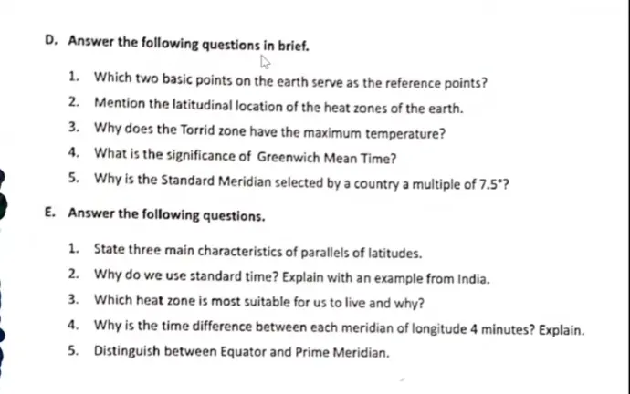
D. Answer the following questions in brief.
Which two basic points on the earth serve as the reference points?
The two basic reference points are the North Pole and the South Pole.
Mention the latitudinal location of the heat zones of the earth.
Torrid Zone: Between the Tropic of Cancer (23.5°N) and the Tropic of Capricorn (23.5°S).
Temperate Zones: Between the Tropic of Cancer and the Arctic Circle (66.5°N), and between the Tropic of Capricorn and the Antarctic Circle (66.5°S).
Frigid Zones: North of the Arctic Circle and South of the Antarctic Circle.
Why does the Torrid Zone have the maximum temperature?
The Torrid Zone receives the most direct sunlight throughout the year as the sun's rays are nearly perpendicular to the Earth's surface in this region.
What is the significance of Greenwich Mean Time?
Greenwich Mean Time (GMT) serves as the global time standard. It's the mean solar time at the Royal Observatory in Greenwich, London, and is used as the basis for calculating time zones around the world.
Why is the Standard Meridian selected by a country a multiple of 7.5°?
The Earth rotates 360° in 24 hours, meaning it rotates 15° per hour (360/24 = 15). Since 7.5° is half of 15°, it allows for time differences in 30-minute intervals, which is often more practical than just full-hour differences.
E. Answer the following questions.
State three main characteristics of parallels of latitudes.
Circles: Parallels of latitude are circles running east to west around the Earth.
Decreasing Size: They decrease in size as they move away from the Equator towards the poles.
Constant Distance: They are equidistant from each other.
Why do we use standard time? Explain with an example from India.
We use standard time to avoid confusion caused by local time differences within a country. For example, India has a vast longitudinal extent. If each location followed its own local time, there would be significant differences between the east and west. India uses 82.5°E longitude as its Standard Meridian, which is 5 hours and 30 minutes ahead of GMT, providing a uniform time across the country.
Which heat zone is most suitable for us to live and why?
The Temperate Zones are generally considered the most suitable for living. They have moderate temperatures and distinct seasons, which support a wider range of agriculture and human activity. Extreme heat or cold in other zones makes them less hospitable.
Why is the time difference between each meridian of longitude 4 minutes? Explain.
The Earth rotates 360° in 24 hours, which means it rotates 15° in one hour (360/24 = 15). One hour is 60 minutes, so each degree of longitude represents 4 minutes of time (60/15 = 4).
Distinguish between Equator and Prime Meridian.
Equator: An imaginary line circling the Earth halfway between the North and South Poles. It's a line of latitude at 0° and divides the Earth into the Northern and Southern Hemispheres.
Prime Meridian: An imaginary line running from the North Pole to the South Pole through Greenwich, England. It's a line of longitude at 0° and divides the Earth into the Eastern and Western Hemispheres.
Let me know if you'd like any of these points expanded upon!